Burnt
Meadow Mountain
Zodiac
Skiway
Brownfield,
ME
1971-1982
History ~
Recent Photos
History
Before letting me tell you about the history of Burnt Meadow Mountain,
let me first thanks Mr. Charles
Harmon, of Brownfield and the librarian
at the Brownfield Library. In November of 1998 my friend Chris Vaccaro and
I went to find this area, but found it mostly overgrown behind some houses.
We stopped by at the town library and met with the librarian. She
suggested we meet up with the Harmon family who lived right up the road.
At their
house Mr. Harmon, who was on Burnt Meadow Mountain Recreation Association
Board, met with me to discuss the ski area. He allowed me to Xerox some articles about this ski area.
This was most helpful, without
these articles this history would be very hard to write! Amazingly
enough, one of the articles showed the original plan of the mountain which
I have included at the bottom of this page. Him and his wife Mary were very
gracious in allowing us to interview them.
Burnt Meadow Mountain itself
was formed on a geological hotspot,
which had also formed Pleasant Mountain. In 1947 a large forest fire destroyed much of the Brownfield area, and
lots of acreage around Maine itself. I believe that this was called
"The Summer That Maine Burned." In fact, 85% of the town was completely
destroyed.
|
By 1965 the town had tried to bring industry back to the area but had little
success. The town turned to another idea, recreation, and had the
town zoned for recreation by 1965. Brownfield has several lakes,
ponds, streams, and medium sized hills, so this seemed to be a good idea.
A grant of $6200 was given to the town to study the prospects of opening
a ski area. In fact, the report generated from this grant suggested
that the area "could become one of the top ski areas in Maine."
June 25, 1967 saw the Farmer's Home Administration authorizing a lone of
$275,000 to the Burnt Meadow Mountain Recreation Association (BMMRA) to
finance the development of the ski area. This was the impetus needed
to get the area going.
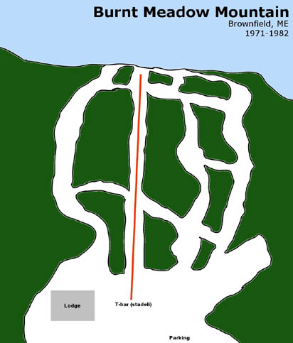
Originally, the area planned to have a 700 foot vertical drop, a 3200 foot
T-bar lift, and a northeast exposure. The T-bar would have a mid
mountain unloading station, "which would give access to the mountain's
snow fields excellent for beginners and youngsters." 4 trails, some
exceeding a mile in length were planned, with difficulties varying from
novice to expert.
Here's the original trail map from a newspaper
article.
|
|
In Mid-March, 1968, the Association was within $7000 dollars to start construction
of the ski area. Most of this money would be gathered from the local
townspeople, said the President of BMMRA. 150 members were sought
for membership in BMMRA.
Even though the money was not immediately available, the engineering firm
which developed the mountain, Wright, Pierce, Barnes and Wyman had "enough
faith to go ahead planning and laying out the trails."
|
Thanks to Bruce Morin
from Ski East,
NELSAP now has a patch
of this area:
|
Unfortunately, three years would pass until the area would actually see
the construction. Construction of the T-bar and access road began
in the middle of November. The T-bar was built by Seaward Construction
Company of Kittery and was 3148 feet long from the base to the top, had a
vertical of 675', went 475'/min and had a capacity of 760 skiers/hour
(Skilifts.org).
"Three trails will be open during the first season of operation, from 3600
to 5200 feet. A fourth trail is planned for the following season
after snow conditions will be studied." Plans were also to light
the area for night skiing.
The area opened for the 1971-1972 season. However, due to several
bad snow seasons and completion from other nearby areas, Burnt Meadow Mountain
never developed beyond the initial stages. A pony lift was installed
at one point during the 1970's, most likely for the beginner area.
The start of the following decade, 1980, saw a change in ownership of the
mountain. Wendell Pierce, owner of the Big Rock Ski Area up in Mars
Hill, purchased the area, mainly for the lifts. Not only that, but
the area changed names to Zodiac Skiway, I'm not sure of the exact reason
why. The town did not want him to remove the lifts, so his daughter
ran the area for several years. The area kept losing money and closed
around 1982.
Today, nature has almost completely taken over this area. Tree growth
almost completely obscures the trails, but the lift remains. |
|
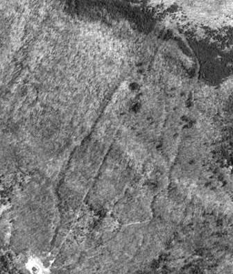
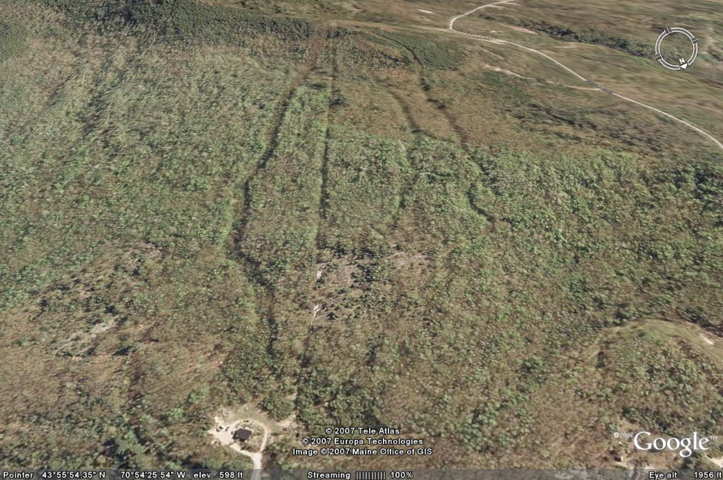
An overhead view of the
area today. Not much to see, as all the trails have rapidly grown in,
but enough to get the gist of the area.
|
Kim Lisa Kreiton
is a granddaughter of Charles
and Mary Harmon and has
some more info: I am a granddaughter of Charles and Mary Harmon of
Brownfield, ME who helped in the Burnt Meadow Mtn ski area project.
Charles' mother Hazel, my Nana, worked on the cafeteria line. I believe
there were other family members involved in the operations too.
My mom sewed ski suits for my
sister and me: overalls and a jacket with a large "saddle" pattern on
the front and back. She cut one suit out of bright red and the other out
of hunter orange quilted fabric, then reversed the pieces so we each had a
wild-colored suit! A ski instructor - ski patrolman - lift operator was
named Roly, and I remember him as being lots of fun. My sister remembers
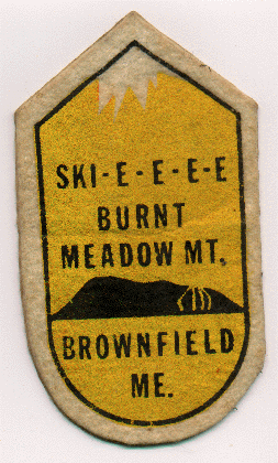
having the Ski-e-e-e- patch (see above patch as an example) on her jacket.
|
|
Chris Bradford
has checked out this area: There isnt' much left of
Burnt meadow. The t-bar is
surprisingly intact, still with all the t-s hanging!
It's confirmed that it is a "Stadeli"
lift, which makes it an extremely rare t-bar.
IMHO, it's a very well built t-bar... larger
than most. The lift itself is
pretty long... 3000' ft?
It's a long ride up! Burnt
Meadow is a fairly large place, looks like it had
some good runs. The upper 100' or
so is very steep terrain.
The whole place is very grown over... I was able to view it
from a distance and there isn't much visible. The base lodge is being lived in.
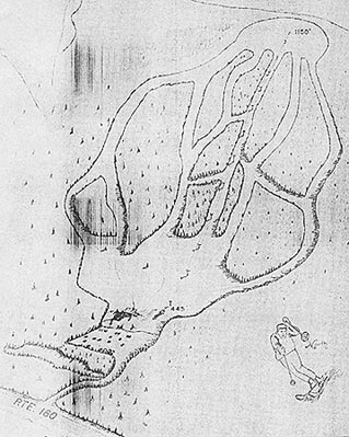
Here's
a map that Chris drew of the area, from a trail map sign he saw inside
the old base lodge, now a private home (he had permission to check it
out).
Carl
Chambers also confirms that the lift is still standing.
|
|
|
 |
A more
recent Google Earth Image shows the trails have grown in but are still
visible. Thanks to Mike Campbell for sending this along. |
Recent
Photos
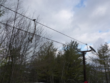
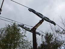
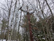
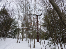
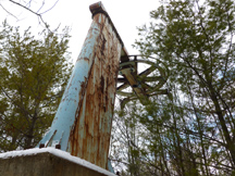
Many thanks to
Carl Chambers who shared with us these photos he took on Jan 20, 2014 of the
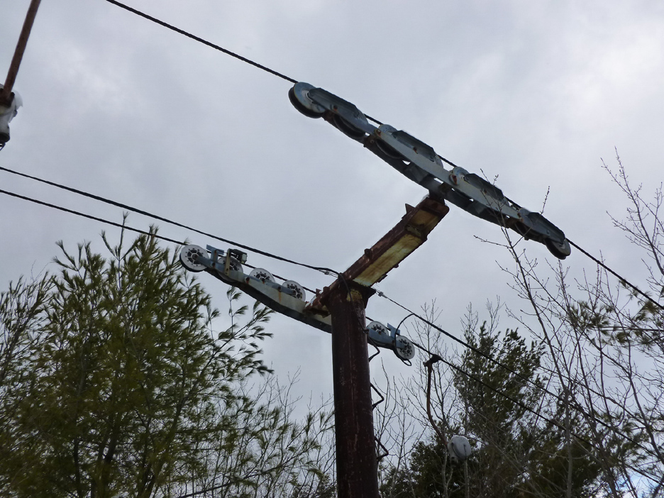
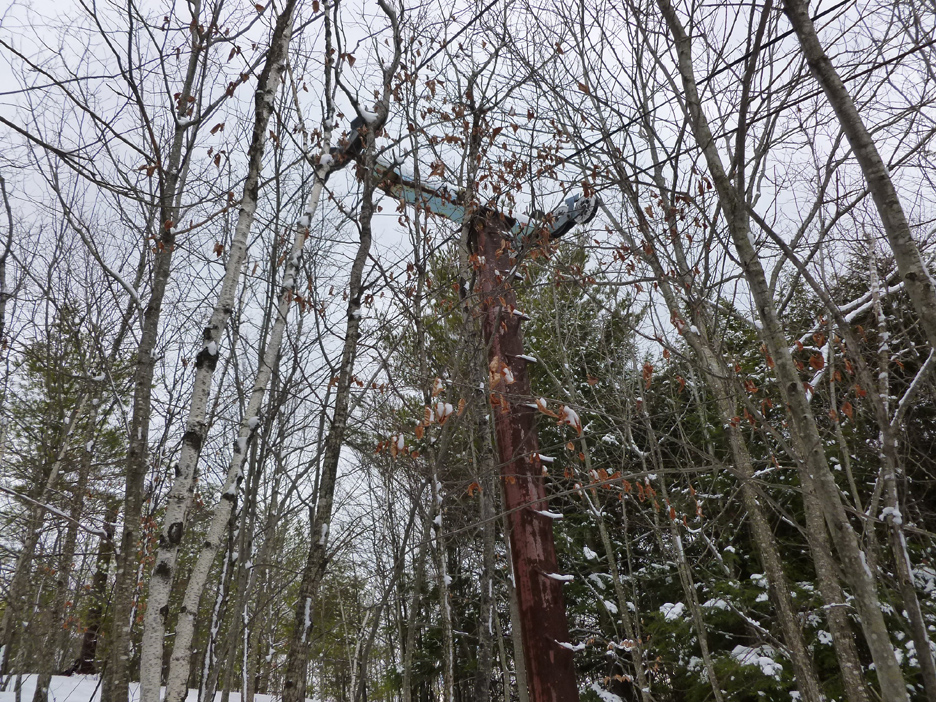
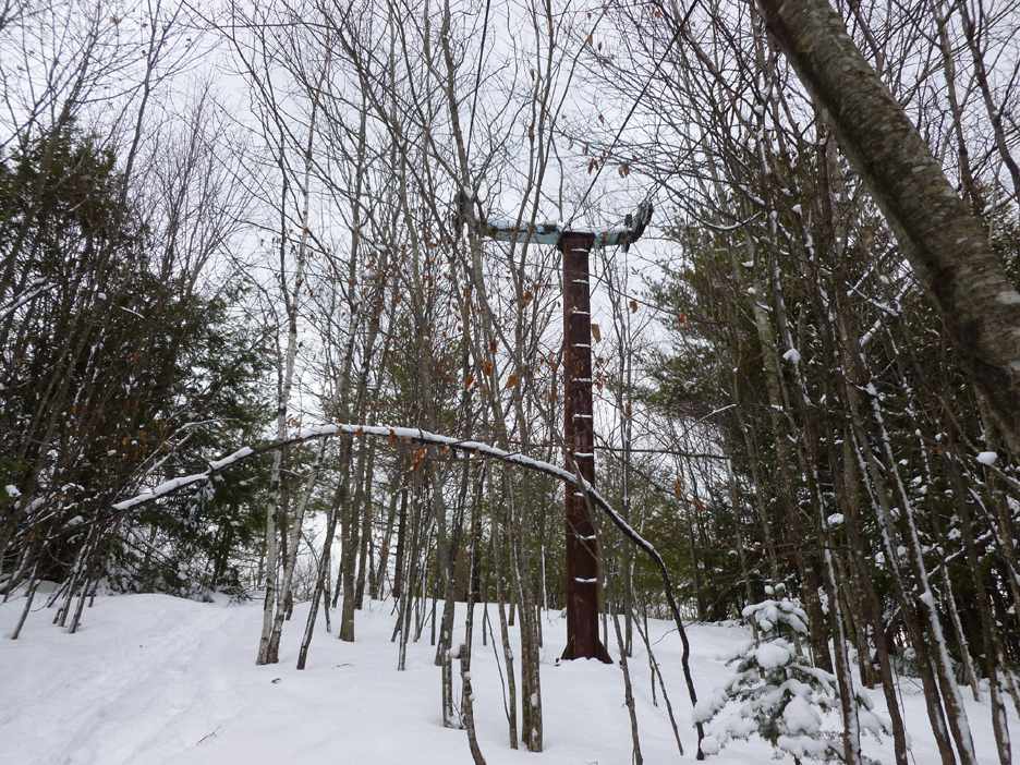
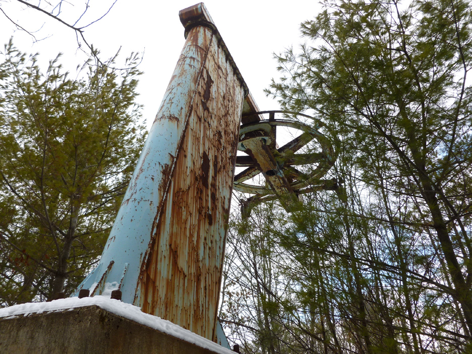
lift at Burnt Meadow Mountain. As you can see, the lift is still standing, as is
the cable and T-bar and carriers - quite remarkable after 30 years. The liftline
is now quite grown in as well. Click on each image for a larger version.
 |
 |
 |
 |
 |
| Lift
tower and T-bar carrier still on the line. |
Close
up of tower and carriers. |
Lift
tower. |
Lift
tower near summit. |
Lift
return. |
If you have further information
on this area just let us know.
Last updated: Jan 21, 2014
The following sources
were used for compiling the history of this area:
Briggs, Linda.
"Burnt Meadows Mountain Ski Area Dream Nearing Reality" Portland
Press Herald, Nov. 24, 1971.
Eastern Ski Map, 1979
and 1980
Moorehead, Robert M.
"Only $7000 Needed to Start New Recreation Area" Maine Sunday Telegram,
Mar. 17, 1968
Parkinson, Glenn.
First Tracks. Auburn: Spectrum Printing, 1995.
Head
back to Lost Maine Ski Areas
Head
back to the Main Page