*This area is flagged for major updates**
Before getting into the ski history of Mt. Agamenticus, let me first thank Dave Hilton, who has helped me with the history of this mountain. All of these pictures on this page are courtesy of his homepage, Agamenticus. This page has more great pictures of this mountain, including the development of the mountain in 1965, the opening ceremonies, and while it was active. Take a look!
Mt. Agamenticus is a very unique mountain for its location. It is located just a few miles from the Atlantic Ocean in York Maine, having an elevation of 691 feet. Spectacular views of the White Mountains and the Atlantic Ocean are visible from the summit. It has the highest elevation of any hill within its distance to the ocean from Portland Maine to Brownsville Texas (with Blue Hill, MA coming in a close second at 635 feet).
I first discovered this mountain in the early 1990's, as my family vacations in the town of York every summer. My parents remember there being a ski area on the mountain, so one day we decided to explore it. We drove up the auto road to the summit, where those spectacular views existed. I was impressed by the whole area, especially the ski area. Details of what it is like today follow at the end of this section.
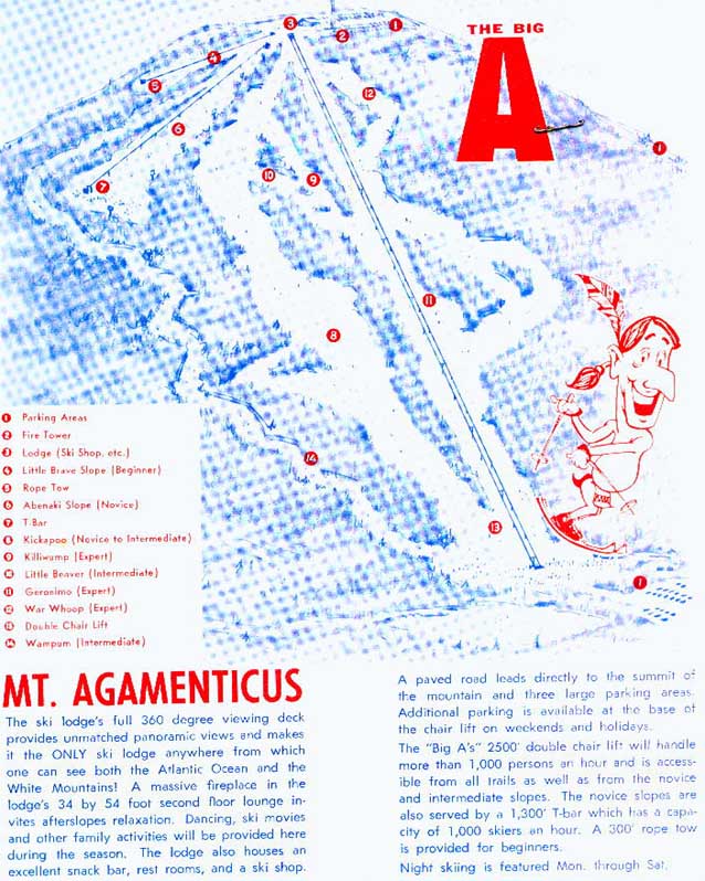
The mountain was developed during 1965, and opened for the 1966-1967 ski season. An opening ceremony was performed in 1966, which appears on Dave Hilton's page. The trail map appears below from this period.
1968
(Unknown ski guide)
Mt Agamenticus took a few years to reach its full size. In 1968, it had a chairlift, T-bar, and rope tow, with skiing on 3 trails and one slope. There was night skiing, a ski shop, summit lodge, and snowmaking. It operated daily.
Old phone number: 1-207-363-5190
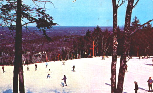
1970
This postcard was taken in 1970, and shows the beginner slope and the T-bar lift.
1973-1974
(Ski Guide to the Northeast)
The following listing is from the last year that Agamenticus operated. Bad snow and a poor snowmaking system (not helped by sea breezes which had lots of salt), plus the energy crisis made the area close.
Vertical Drop: 500 feet
Exposure: Northwest
Rates: Weekday-$4.00 adult, $3.00 junior. Weekend-$6.50 adult, $4.50 junior. Season-$60.00 adult and junior.
Lifts: As they appear above in the trail map.
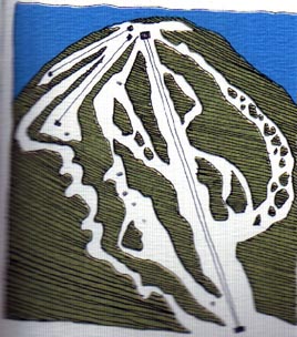 Agamenticus'
trail map the year they closed. A new trail had been added on the right.
Thanks much to Dave Hilton for this brochure he provided to NELSAP!
Agamenticus'
trail map the year they closed. A new trail had been added on the right.
Thanks much to Dave Hilton for this brochure he provided to NELSAP!
Late 1980's
(from Dave Hilton)
The double chairlift is finally removed after 15 years.
Today
(from multiple personal tours)
Mt. Agamenticus is one of the most explorable closed ski areas I have seen. It has an easy location to get too (off Mt. Road in York), ample parking, hikable trails, and now even horse stables. The summit lodge is still used for functions. Here's what's left of the three main areas:
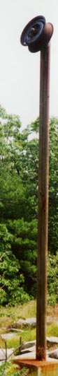
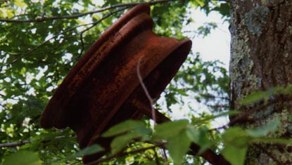
Rope Tow
The rope tow is mostly gone, although one tower remains near the summit, as well as one wheel hub near the bottom of the beginner slope. This slope is rapidly overgrowing. One snow packer exists near where the top of the rope tow used to exist.
Here are two pictures of the old rope tow. The tower on the left is at the summit of the old lift while the wheel to the right is found towards the bottom of the slope.
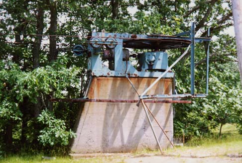
T-bar
The T-bar is still standing, in remarkable shape after being closed for 25 years. The towers are painted blue now, unlike the old red from the postcard above. The engine was located at the top, typical of an upside down mountain. This engine is still in remarkable shape. Each tower is still standing, as well as the cable, but the individual T-bars are gone. Abenaki Slope has overgrown a good deal, but erosion has prevented the complete overgrowing of this slope. At the bottom, the T-bar shack is still standing, and some trees have grown in at the bottom bullwheel.
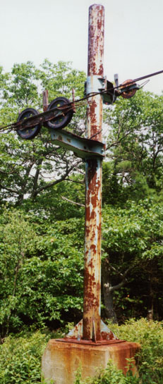
 The
T-bar summit engine.
The
T-bar summit engine.
 One
of the old T-bar towers, and although its rusted you can see the blue paint.
One
of the old T-bar towers, and although its rusted you can see the blue paint.
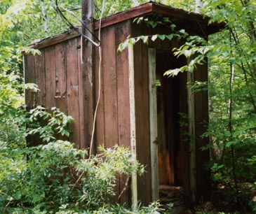 The
T-bar base shack.
The
T-bar base shack.
Chairlift
Most of the trails near the old chairlift line have overgrown quite a bit. However, the character of the trails are still quite evident, as tree islands still exist. The chairlift cement bases are all that remains of the lift. If you hike to the bottom and reach the old parking lot, look up at the mountain. Its hard to imagine that this was once a thriving ski area. Unfortunately, even the old chairlift line has completely overgrown and is no longer visible.
If you do hike to the bottom, you can complete a nice loop by hiking the old base access road. When you reach another dirt road, turn left. Follow this to the base of Mt. Agamenticus (about 1 mile). From there it is another 3/4 mile to the summit via the auto road. Good luck if you decide to hike it!
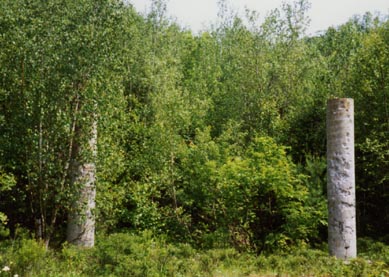 Believe
it or not...the double chair used to pass between these two cement columns!
Believe
it or not...the double chair used to pass between these two cement columns!
How to get to Agamenticus:
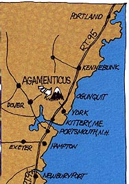 Just
off the highway at York, just below the tolls. Take Chases Pond Road to
Mountain Road, then drive the auto road.
Just
off the highway at York, just below the tolls. Take Chases Pond Road to
Mountain Road, then drive the auto road.
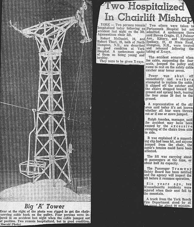
Here's an article from Dave Hilton that explains what happens when you rock the chair on a lift!